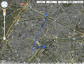
During the Christmas vacation, I have done my new prototype 2.0 and named it "Paris Je T'aime" (same name as a movie). The reasons I choose Paris as my city to make prototype 2.0 is based on the following reasons:
1. Google gets both maps and street view web services in Paris. This might be the most important reason I chose Paris. Without Google street view and maps, my project will not be achieved.
2. I attempt to tribute to my inspiration, the photo set of Michael Wolf.
3. Though Paris and London is only separated by English channel. However, it is faraway for me because of visa and I could not attend there whenever I want like others.
4. I have only been Paris once when I was ten and memories of the city is almost gone. For that reason, Paris is always fascinating for me.

I choose the route from Arc de Triomphe to Eiffel Tower, the two most representive buildings and sightseeing spots in Paris, because I want to present the video as a journey video which is taken by tourist. The length between these two places is approximately 2.6 kilometers. Normally it takes five minutes by vehicle.
In this prototype practice, I try to combine two Google programs - street view and earth together. Capture the pictures from both software and website and put pictures in Final Cut Pro and convent into film format. Another attempt I try to achieve is that I add the frame rates a little bit (8 frames/per second) to make it less like a smooth video but a rough film. Here is the prototype two video "Paris Je T'aime".
In this one minute and thirty-five seconds video, there are approximately 350 pictures being used in it. However, my friend and I both feel it too plain and the pace is slow. I think in next version of prototype, I need to try some different elements like pause or reverse and also adjust the frame rates to see if it is suitable or not.
沒有留言:
張貼留言